Project Description
Project Deliverables
Basin asbuilt volumes, 3D point cloud, digital surface model, and high-definition orthomosaic map.Construction progress images and video, cut/fill stockpile volumes, basin asbuilt volumes, 3D point cloud, digital surface model, and orthomosaic map.
Project Details
- Aircraft: DJI Phantom 4 RTK
- Flight Altitude: Approximately 200-feet AGL
- Mission Type: Aerial grid
- Images Captured: 272
- Imagery Type: RGB Photo
- Total Project Area: Approximately 22-acres
- Flight Airspace: Class G
- Location: Maricopa, Arizona
- Project Category: Construction & Inspections

Project Description
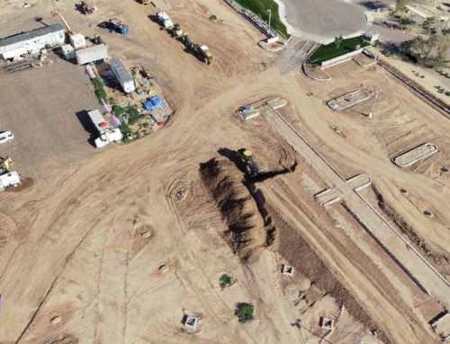
Aerial grid mission above a new construction development site in Maricopa, Arizona. The DJI Phantom 4 RTK was flown at an elevation of approximately 200-feet AGL to capture the progress of the construction site and to accurately measure the volume of the pond.
Using photogrammetry processing software, a 3D point cloud, full-site orthomosaic map, Digital Terrain Model (DTM), and Digital Surface Model (DSM) were all produced. Precise pond volume measurements from the 3D point cloud were calculated within hours of taking off (pond volume ~4,776,820-gallons).

A full-size orthomosaic map [to the left] is created from stitching hundreds of photos together during photgrammic processing. The orthomosaic image provides a geometrically orthorectified 2D view of the entire site, which can be used to measure true distances between points or objects.
The image [to the right] is taken from the full-site orthomosaic map of the project site [as seen above]. Not only are orthorectified images geometrically accurate, but they are also highly-detailed, allowing for accurate measurements and real-world 2D representations of a project sites of any size.

Related Projects

Construction Site Pond
Project Deliverables Basin asbuilt volumes, 3D point cloud, [...]

Parking Lot Construction Progress
Project Deliverables Construction progress images and video, cut/fill [...]