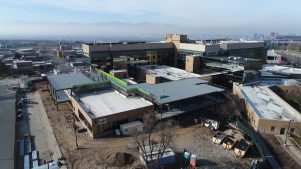
CONSTRUCTION & INSPECTIONS
EWL utilizes remote sensing data for aerial investigations of construction sites. Volumetric calculations, asset management analysis, construction progress photos, 3D site layouts, and stockpile measurements can be delivered to owners and investors faster and with greater accuracy than ever before.
VIRTUAL RECORDS
A firm of engineers, scientists and technology gurus who have learned to leverage the latest sUAS (drone) technologies to generate a real-time record in high resolution.
Utilizing the benefits of sUAS (drone) technology we can assist your next project to achieve cost saving results unimaginable just a few years ago throughout numerous industries. The data can be provided as individual high resolution photos, a single high resolution stitched overall site photo, site infrastructure measurements, quantities or surfaces. Inspections can be done rapidly and safely with repetitive accuracy.
Contact us for a no-obligation review of your project challenges and our team of professional will schedule a demonstration
SIMPLIFY INVESTIGATIONS
Simplifying the estimating, pre-project planning, construction progress reporting and project closeout processes equals increases in revenue

Surveys & Topography
Produce full-site contour maps and digital elevation data for any construction site.

Measure Stockpiles
Volume calculations for stockpiles, storage tanks, and asset infrastructure of any size. Saves time and money, while improving the safety of the data-gathering process of traditional stockpile measuring.

Cut/Fill Calcs or Basin Asbuilt Volumes
Using a 3D point cloud, the fill volume of any basin or pond can be calculated with ease.

Excavation Records & Photo Documentation
Obtain images, videos, and 3D models of construction sites to analyze digital records for any phase in the construction progress.
Drones overall will be more impactful than I think people realize in positive ways to help society
Industry Verticals

CONSTRUCTION & BUILDING
sUAS technology can enhance the safety, security and recording of jobsite information with drone applications in construction. Ever increasing data collection, recording and measurement methods can improve the accuracy of the construction process. Drones complement the changes in our design of projects through the building and end-user delivery process. Streamline the reporting, measuring and BIM integration processes being implemented into the operation of construction sites.

PUBLIC SAFETY
sUAS technology is saving and protecting lives (humans, animals and plants). There are several day-to-day uses for police, fire and first responders in creation of models for accident recreation, risk assessment and planning for the what-if scenarios. There are also numerous applications during an disaster emergency operation such as infrared mapping of wildfires or volcano activity, search and rescue investigations, hurricane, earthquake, flood or other disaster surveys and unfortunately many more. Uses of drones, however, allow for quick analysis of a situation to allow emergency managers to mobilize the most effective resources in a much more efficient manner than just a few years ago.

INFRASTRUCTURE & INSPECTIONS
sUAS technology has altered the ability to safely document and record information with drone applications in inspections. Highly accurate high definition images, infrared data or even sampling activities can now be done with drone technology. These advances in technology are reducing the dependency on human inspection in climbing, crawling under or entering facilities while in operation. This brings safe and efficient processes to confined space entry, climbing towers or requirements rerouting of traffic during the inspection process.

AGRICULTURE & RANCHING
sUAV technology is changing the way we farm by the ever-increasing drone applications in agriculture. Advanced multi-spectral imagery capturing sensors allow a new perspective to view fields by capturing photos from narrow bands of the visible and infrared spectrum resulting in ultra precise use of water and fertilizer. Ranching and feed plots can also utilize drones to improve and enhance the efficiency of these operations.

CINEMA & PHOTOS
sUAS technology allows us to put a high definition camera at elevation to easily capture different perspectives. New shots are being able to be more implemented into workflows never previously imagined. Understanding cameras and post-processing film software is still as important a skill as flying the camera to obtain high quality and repeatable results. Drones are bringing new ways to capture video and photos of real estate, events, landscapes and our lives outside the applications in the Architecture, Engineering and Construction industry.

BUSINESS OPS & TRAINING
Applying sUAS technology successfully requires business to understand new regulations, change workflows and incorporate training programs. To ensure compliance and safety in any drone program learning from companies that are forging the way is critical to efficiently implement drones into any business operation. Data capture from a flying camera is also increasing the need for more complex computer hardware systems, new software for processing and IT platforms for storage and delivery of the complex data achieved from the flying technology.

MINING & EARTHWORK
sUAS technology can enhance the safety, security and recording of data with drone applications in mining and earthmoving. Ever increasing data collection, recording and measurement methods can improve the accuracy of the heavy civil and mining process. Streamline the reporting, measuring and measurements with significant advancements in the accuracy of the field collected data from the operation of sites dependent on stockpiles of material.

SURVEYING & MAPPING
sUAS technology allows us to collect real-world data like never before. Creation of aerial images that are orthorectified, surveying, mapping, photogrammetry, digital point clouds, orthomosaics, topography, contours, digital surface models, digital elevation models, volume calculations are just a few of the common uses. Drone technology is allowing for data capture to generate of high-quality information and calculations from aerial imagery for use in nearly every industry without reliance on historical satellite images or expensive airplane captured data. Decisions can be made today from the data captured today from near-field remote sensors mounted on drones.
CONSTRUCTION & BUILDING
sUAS technology can enhance the safety, security and recording of jobsite information with drone applications in construction. Ever increasing data collection, recording and measurement methods can improve the accuracy of the construction process. Drones complement the changes in our design of projects through the building and end-user delivery process. Streamline the reporting, measuring and BIM integration processes being implemented into the operation of construction sites.
Recent Projects
Examples of some of our recent project experience includes:

