Project Description
Project Deliverables
Construction progress images and video, cut/fill stockpile volumes, basin asbuilt volumes, 3D point cloud, digital surface model, and orthomosaic map.
Project Details
- Aircraft: DJI Phantom 4 Pro, DJI Phantom 4 RTK
- Flight Altitude: Approximately 225-feet AGL
- Mission Type: Aerial Free Flight
- Images Captured: N/A
- Imagery Type: RGB Photo
- Total Project Area: N/A
- Flight Airspace: Class G
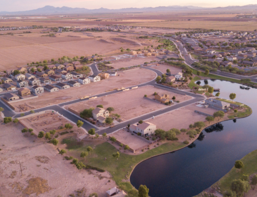
- Location: Chandler, Arizona
- Project Category: Construction & Inspections

Project Description
EWL Aerial Tech can take aerial construction progress images from the perfect in-flight angle. With precise RTK accuracy, EWL can take images from the same location, altitude, angle to ensure that the progress of any construction project is captured regularly. EWL Aerial Tech performed an aerial grid mission of the flight, then used photogrammetry software to capture the project site in a point cloud in order to calculate the volume of a parking lot stockpile.
EWL regularly documents the progress of a construction lot in Chandler, Arizona on a regular basis. With RTK and waypoint technology, EWL’s drones can perform routine inspections, videos, and images from the same location, whenever the construction schedule requires. A progress video can be made by stitching together images and video for a seamless transition between all phases of the construction project.

EWL can also perform aerial grid missions over construction sites for mapping and 3D modeling applications. The progress of a project can be tracked with a 3D point cloud or orthomosaic, instead of an image, creating an interactive and measurable full-size data set from any phase of the construction, which can be saved for records.
Aerial grid missions of construction sites can also be used for calculating physical assets and measuring asbuilts.
The image on the left shows a stockpile from the parking lot project. With sUAS technology and advanced processing capabilities, EWL Aerial Tech can document any phase or moment of a construction project.
Related Projects

Construction Site Pond
Project Deliverables Basin asbuilt volumes, 3D point cloud, [...]

Parking Lot Construction Progress
Project Deliverables Construction progress images and video, cut/fill [...]