Project Description
Project Deliverables
3D point cloud, digital surface model, and high-definition orthomosaic map.
Project Details
- Aircraft: DJI Matrice 210 RTK
- Flight Altitude: Approximately 240-feet AGL
- Mission Type: Multi-mission grid
- Images Captured: 1,681
- Imagery Type: RGB Photo
- Total Project Area: Approximately 51-acres
- Flight Airspace: Class G
- Location: Portland, Oregon
- Project Category: 3D Map & Model

Project Description
The DJI Matrice 210 RTK was flown at approximately 240-feet AGL in a multiple grid mission above the VA Portland Medical Center in Portland, Oregon. The site sits atop a steep hill in Portland’s Marquam Hill district, so obtaining accurate topographic information about the site was vital for the project. A full-site orthomosaic, digital surface model (DSM), and 3D point cloud model were produced for the site.
EWL can perform aerial inspections in a diverse range of topographic conditions and landscapes. The VA Portland facility not only sits atop a steep hill, but is also scattered with tall buildings and trees, giving this project site a relatively erratic surface. EWL’s drones can obtain high-quality photogrammic data of any surface type, whether it is flat or covered in buildings and trees.

The image [on the left] shows a small section of the orthomosaic map of the VA Portland Project site. Using the topographic data from the sUAS-created digital surface model and spatial analysis tools, EWL was able to identify the areas on the campus that exceed a certain slope, as shown by the areas highlighted in red.
Related Projects

VA Portland Medical Center
Project Deliverables 3D point cloud, digital surface model, [...]

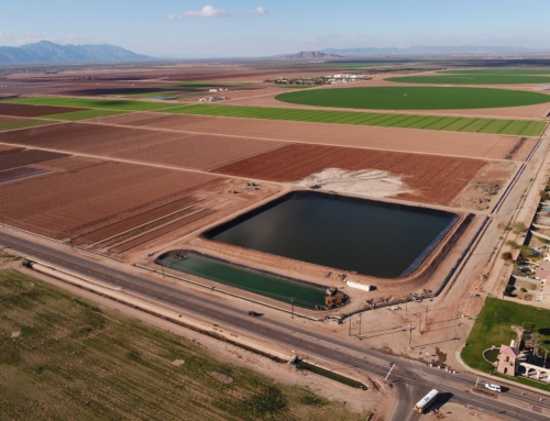
University of Arizona Agricultural Research Pond
Project Deliverables Basin asbuilt volumes, 3D point cloud, [...]

Site Inspection
Project Deliverables 3D point cloud, digital surface model, [...]